Aquius
Live Demonstrations
Here+Us - An Alternative Approach to Public Transport Network Discovery
This section contains examples of Aquius displaying public transport networks, plus hosted tools for constructing Aquius datasets:
- Barcelona - comprehensive urban network built from multiple sources, including strategic analysis of network changes.
- FlixBus - long-distance international European network, containing extensive cabotage (pickup and setdown) restrictions.
- Great Britain - national and local networks.
- New York City - one of the largest American urban networks.
- Paris - one of the largest European urban networks.
- Spanish Railways - traditional national railway network, including split trains and mixed products.
- York - basic small city network, including lasso routes.
- Tools - build networks from GTFS or GeoJSON, merge network together, or bulk analyse Aquius data.
Barcelona
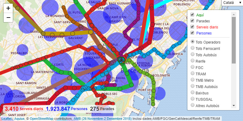
Àrea Metropolitana de Barcelona (26 November-2 December 2018): Snapshot of all non-tourist scheduled public transport within the Àrea Metropolitana de Barcelona (AMB) - more information about this dataset.
AMB Vortex (26 November-2 December 2018): As above, but in a fixed coordinate grid, ideal for strategic analysis.
The AMB Vortex map includes sample proposed network changes - Diagonal tram (direct on-street route), L9/10 connection (with all proposed stations, except those in Zona Franca), and Rodalies 2026 (suburban railway as proposed in 2006). These examples are not intended to replace detailed (but specific) analysis of proposals in isolation. Rather to show how quite different proposals can be considered in their shared context - which for cities can otherwise be extremely difficult to comprehend. Aquius doesn’t just allow networks to better understood: Even without a proper interface (proposed routes currently need to be outlined in GIS software, base networks filtered appropriately, and the combination rebuilt), the networks demonstrated here can be built and probed in a matter of minutes.
FlixBus
FlixBus (20-26 August 2018): Snapshot of all European FlixBus (and FlixTrain) services - more information about this dataset.
The FlixBus network is almost impossible to communicate on a fixed map because its service patterns are often defined by cabotage restrictions, especially in Iberia and the Balkans. Such cabotage restrictions may prevent FlixBus conveying passengers within countries or regions, often rendering the destinations available to passengers quite different to the route taken by the vehicle. This added complexity is not a limitation for Aquius, which always draws its route map from a user-specified here. FlixBus represents an extreme test case of cabotaged international operation, since on some routes almost every place served is defined with a different set of boarding and alighting restrictions. FlixBus host their own dynamic network map, however this can feel laggy, and does not give any indication of service frequency - destinations with one bus a week are shown just as prominantly as destinations with one bus an hour. The Aquius dataset is relatively large - almost 1 MegaByte uncompressed, even without headcode information and day-by-day service filters (which can potentially be built from GTFS) - but is smoother to use and more indicative of services.
Great Britain
Great Britain Public Transport by Ward, weekdays/operating group April 2019, all days/mode February 2020, and all days/mode February 2021 (in COVID-19 lockdown): Snapshot of all scheduled services except aviation, mapped between Wards, ideal for strategic analysis of local transport - more information about this dataset.
Great Britain Public Transport by District, weekdays April 2019: Snapshot of all weekday scheduled services except aviation, mapped between Districts, ideal for strategic analysis of longer-distance transport - more information about this dataset.
Similar maps are available by traditional county and region/nation, primarily for long-distance analysis.
All are Vortex-style maps that groups stops by their administrative geography. Such aggregation just about makes it possible to contain any entire country within a single dataset, although the Ward maps is large (over 5 MegaBytes).
Great Britain National Rail (weekdays, January 2019): Snapshot of all weekday passenger train service patterns across Network Rail - more information about this dataset.
The GB Rail dataset makes extensive use of dummy waypoints to show the route taken by trains, regardless of their stops. This results in a relatively neat map where service totals at stations are not automatically the same as the sum of the links passing those stations.
New York City
New York City (January 2019): Snapshot of every scheduled public transportation service within the five Boroughs of New York City - more information about this dataset.
Paris
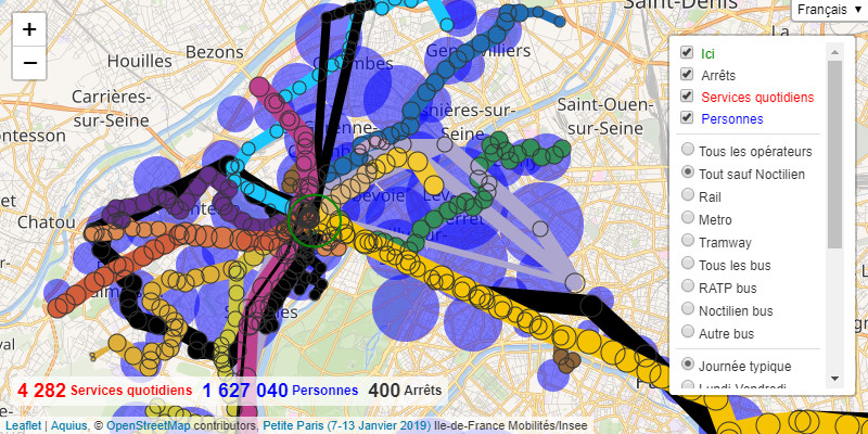
Inner Paris (7-13 January 2019): Snapshot of every scheduled public transport service within the Petite Couronne of Paris - more information about this dataset.
Spanish Railways
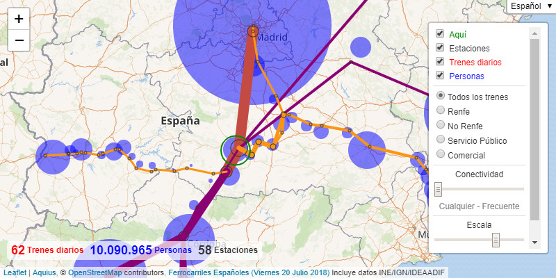
Spanish Railways (Friday 20 July 2018): Snapshot of all non-tourist passenger train services within Spain - more information about this dataset.
Renfe Obligación de Servicio Público: As Friday 20 July 2018 above, but with custom filters for each Renfe state supported product, plus administrative boundaries.
Renfe LD/MD (10-16 December 2018): GTFS extract from the first batch of Renfe open data. The extract excludes Cercanías (most suburban), Feve (metre gauge), Trenhotel (sleeper) and non-domestic services. Unlike earlier data, the extract summarises both directions across a full week, including crude time period analysis.
York
York (January 2019): Snapshot of all bus services within the City of York - more information about this dataset.
Transdev Blazefield (September 2019): Operator-specific network built from GTFS released as part of the Department for Transport’s Bus Open Data initiative.
Tools
GTFS to Aquius
GTFS to Aquius - Tool to convert single General Transit Feed Specification files into Aquius datasets. Also see GTFS to Aquius documentation.
GeoJSON to Aquius
GeoJSON to Aquius - Tool to create Aquius datasets from bespoke geospatial networks. Also see GeoJSON to Aquius documentation.
Merge Aquius
Merge Aquius - Tool to merge Aquius datasets together. Also see Merge Aquius documentation.
Aquius Analysis
Aquius Analysis - Work in progress tool for bulk analysis of Aquius datasets.